
Shoplifting reports within a mile of central Woking rose from 258 to 421 in the year to July 2026. Drugs offences fell by a third and public order by 16%.
Shoplifting reported to police in central Woking rose by 63% in a year. There were 421 reports within a mile of the town centre in the 12 months to July 2026, up from 258 in the year before.
The figures come from police.uk, which publishes every crime Surrey Police records, mapped to an approximate location. The latest month is July 2026.
Overall, recorded crime and anti-social behaviour in the same area rose by 3%, from 3,134 reports to 3,241. So shoplifting is doing most of the rising.
How each type of crime changed
These are totals within one mile of central Woking. The first column covers August 2024 to July 2025, the second August 2025 to July 2026.
| Type | Year to July 2025 | Year to July 2026 | Change |
|---|---|---|---|
| Violence and sexual offences | 1,014 | 1,040 | up 3% |
| Anti-social behaviour | 481 | 501 | up 4% |
| Shoplifting | 258 | 421 | up 63% |
| Public order | 384 | 321 | down 16% |
| Other theft | 247 | 265 | up 7% |
| Criminal damage and arson | 240 | 213 | down 11% |
| Drugs | 117 | 77 | down 34% |
| Vehicle crime | 96 | 99 | up 3% |
| Burglary | 87 | 79 | down 9% |
| Other crime | 64 | 64 | no change |
| Bicycle theft | 51 | 60 | up 18% |
| Robbery | 29 | 35 | up 21% |
| Theft from the person | 34 | 27 | down 21% |
| Possession of weapons | 32 | 39 | up 22% |
| All | 3,134 | 3,241 | up 3% |
The smaller categories swing a lot from year to year. A rise from 29 robberies to 35 is six reports, so treat those percentages with care. The shoplifting rise is 163 extra reports.
When it jumped
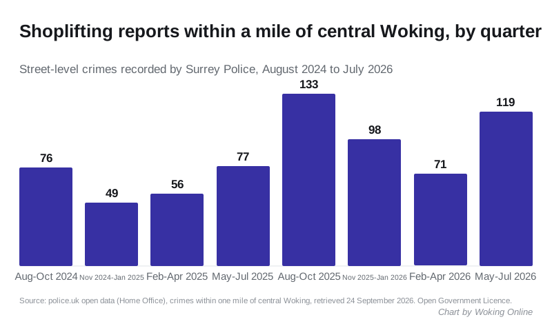
The step change came in autumn 2025. There were 133 shoplifting reports between August and October 2025, against 76 in the same three months of 2024. November 2025 was the worst single month in the two years, with 55.
It eased over the winter, then climbed again. May to July 2026 brought 119 reports, up from 77 in the same months a year earlier.
Where the reports are mapped
Police.uk does not publish exact addresses. It places each crime at the nearest of a set of anonymous map points, some named after a street and some after a type of place. Over the latest 12 months, shoplifting reports in central Woking were mapped:
- 103 on or near a supermarket
- 96 on or near a parking area
- 74 on or near a shopping area
- 57 on or near Chapel Street
The map points hide which shop is which, on purpose. What they show is that the reports are concentrated in the town centre’s main shopping streets and car parks.
How the cases ended
Police.uk also records the latest outcome of each case. For the 421 shoplifting reports in the latest year:
- 189 were closed with no suspect identified, 45%
- 73 were closed because police were unable to prosecute a suspect
- 65 were still under investigation
- 33 were dealt with by a local resolution
- 32 had gone to court or were waiting for a court outcome, or the court result was not available
Outcomes are updated over time, so the most recent cases look more unresolved than they will eventually be.
The other side: public order and drugs down
Not everything went up. Public order offences fell by 16% and drug offences by 34%.
Those figures sit alongside Surrey Police’s view of the town centre’s night-time economy. Responding to the council’s plan to scrap Woking’s saturation zone for licensed premises, Inspector Edward Lyons wrote that police demand linked to the night-time economy “has fallen significantly”. Police counted 268 incidents at ten town-centre premises in a year, and he said much of the total was shoplifting, anti-social behaviour and welfare concerns (police response). The Licensing Committee decides on the zone on 30 September. Read our report on the saturation zone.
What it means for you
- Report it. Shop staff and shoppers can report a theft that is not in progress to Surrey Police online or on 101. Call 999 if it is happening now or someone is at risk.
- Check your own street. The police.uk neighbourhood pages show crime near any postcode, month by month, with the same map points used here.
- Read the figures carefully. A rise in recorded shoplifting can reflect more reporting as well as more theft. The data cannot separate the two.
How we did this
We downloaded every street-level crime and anti-social behaviour record from the police.uk API for a one-mile radius around central Woking, for each month from August 2024 to July 2026. We then added them up by type. The one-mile circle takes in the town centre and parts of the neighbouring residential areas. It is not the whole borough. Police.uk figures can be revised after publication.
For more local reporting, see Woking’s September food hygiene ratings, this month’s new Woking companies and our guide to parking in Woking.
Sources
- Home Office and Surrey Police, police.uk open data, street-level crime and anti-social behaviour within one mile of central Woking, August 2024 to July 2026, retrieved 24 September 2026. Open Government Licence.
- Surrey Police, response to the Cumulative Impact Assessment consultation, Woking Licensing Committee papers for 30 September 2026
Have your say