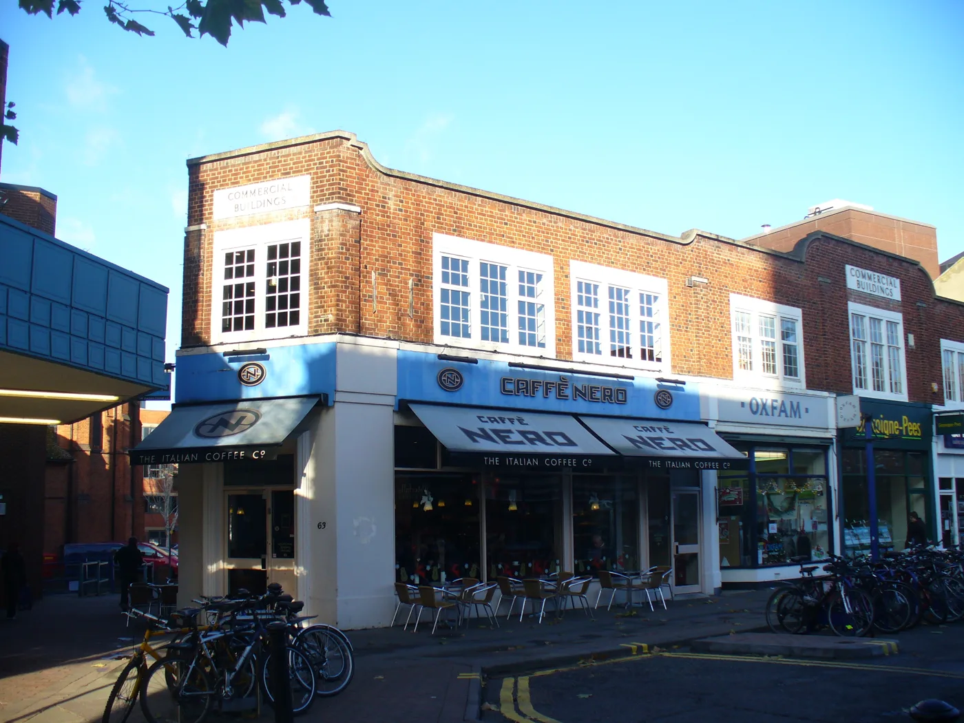

The council wants to add Commercial Buildings (63 to 75 Commercial Way) to the town centre conservation area. Comments close 31 August: what the three draft appraisals propose.
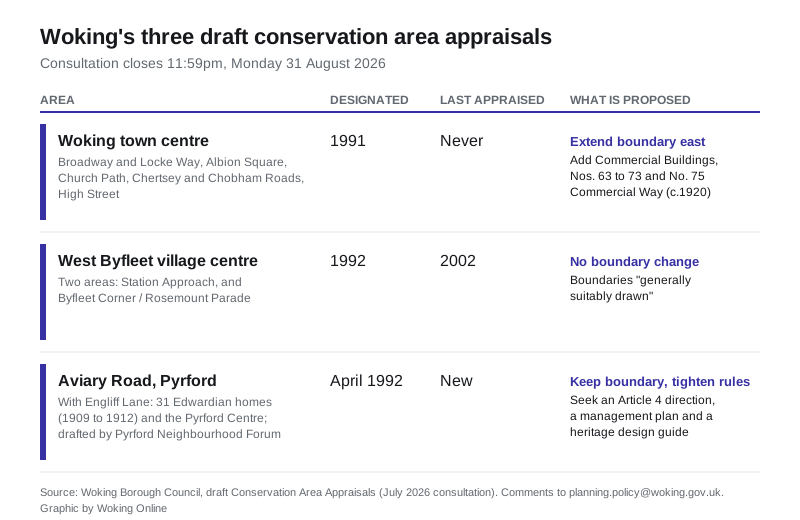
Woking town centre’s conservation area could be extended for the first time since it was drawn in 1991, and residents have until 11:59pm on Monday 31 August to say what they think. Woking Borough Council is consulting on three draft Conservation Area Appraisals: one for the town centre, one for the two conservation areas in West Byfleet’s village centre, and one for Aviary Road and Engliff Lane in Pyrford, written by the Pyrford Neighbourhood Forum with the council.
The headline change is in the town centre. The draft town centre appraisal proposes taking the boundary east along Commercial Way to include Commercial Buildings, the parade of shops at Nos. 63 to 73, and the adjoining No. 75, a range dating from about 1920 which the council describes as showing “vernacular architectural treatment with some Art Deco influences”. Harland House, the 1970s block next to Albion House on the south side of Commercial Way, is deliberately left out: its shopfronts are lively, the document says, but the building itself “is of no architectural merit and contributes nothing to local character”.
The West Byfleet appraisal proposes no boundary change, and the Pyrford one recommends keeping its boundary as it is but asking the council for an Article 4 direction, which would strip permitted development rights so that fences, hedges and front walls need planning permission.
What a conservation area appraisal actually does
A conservation area is, in the words of the 1990 Act the documents quote, “an area of special architectural or historic interest, the character or appearance of which is desirable to preserve and enhance”. An appraisal is the council’s written case for that designation: it walks the streets, records what is historic and what is not, and lists the changes it would like to see. Planning officers then use it when deciding applications inside and next to the area.
The town centre document is candid that this work is overdue. The area was designated in 1991 and, it says, “has not been subject to any formal appraisal, despite the rapid pace of change and development both within it and in the wider town centre”. Two allocated development sites sit inside or partly inside it: UA4 (1 to 12 High Street and 26 to 34 Commercial Way) and UA6 (13 to 28 High Street and 2 to 24 Commercial Way). The appraisal also leans on the borough’s new List of Locally Listed Heritage Assets, adopted in December 2025.
Preparation began some time ago. Councillors and residents’ groups were contacted in November 2021, a workshop was held on 6 December 2021 and a walking study on 10 January 2022, and the draft went to Historic England in March 2026.
The town centre: five sub-areas and a long list of wishes
The town centre appraisal divides the area into five sub-areas: The Broadway and Locke Way; Albion Square; Church Path; Chertsey Road and Chobham Road; and the High Street. Together they are what the document calls “Woking’s original commercial heart”, the streets that were the main shopping area until the modern centres arrived from the 1970s, and where most buildings still have shops below and flats above.
The history section is worth reading on its own. Woking station opened in 1838 as the southern terminus of the line from Battersea; the Albion Hotel, on the site of today’s Albion House, went up in 1856 to 1857 and was rebuilt in 1899; the corner building at Chobham Road and Commercial Way now occupied by the London Stone bar dates from 1874; and Chertsey Road took over as the main shopping street from the 1890s. The street pattern, the appraisal notes, has barely changed since the 1934 Ordnance Survey map.
The “enhancement opportunities” are where residents are most likely to have a view. Among the items the council flags:
- The Broadway: the bus shelters on the south side are “unattractive, and make the space feel dark, enclosed and cluttered”; the vacant plot between Nos. 5A and 8 “shows signs of neglect and vandalism” and could take planting or public art; Regent House at Nos. 19 to 20 is singled out as unsympathetic infill.
- Albion Square: the north side of the railway station “lacks presence and visual interest” and its entrance could be made “far more prominent and welcoming”; the street lamps are “overbearing in their scale” and cast-iron replacements are suggested.
- Church Path: the ground-floor podium of Albion House could be decorated, and the plain northern extension of No. 1 High Street should be creatively reused or replaced.
- Chertsey Road and Chobham Road: the facade of Nos. 19 to 21 is “in relatively poor condition”; post-war infill at Aqua House, Nos. 11 to 17 and Railway House is called unsympathetic; and the document asks that future glazing work start with restoration or secondary glazing rather than PVC.
- High Street: the service yards and parking at the east end of Chapel Street could become “alfresco dining or a pocket park”, and the stretch of the High Street outside the conservation area “suffers from a high vacancy rate which makes the whole street appear shabby and unkempt”. No. 1 High Street, which is locally listed, is recorded as “currently undergoing a sympathetic conversion” in 2026.
None of these is a planning application. They are the council’s stated preferences, which carry weight when applications come in and when public realm money is spent.
West Byfleet: two areas, no boundary change
The West Byfleet appraisal covers the two conservation areas around the village centre, Station Approach and Byfleet Corner/Rosemount Parade, both designated in 1992 and last appraised in 2002. It records “cohesive parades of Arts & Crafts buildings from the late Victorian and early Edwardian periods” built after the railway station opened, and says the mid-rise development on the former Station Approach allocation (UA40), built between 2023 and 2025, “has significantly changed the context of the Conservation Areas”. Its conclusion on boundaries is that they are “generally suitably drawn”, so nothing is added or removed.
Pyrford: 31 Edwardian homes and a push for tighter controls
The Aviary Road and Engliff Lane appraisal is the Pyrford Neighbourhood Forum’s work, based on its own resident surveys in 2024 and 2025. The area was designated in April 1992 and takes in 31 Edwardian houses built between 1909 and 1912, plus the locally listed Victorian Pyrford Centre. Engliff Lane, it says, is recorded as a route since at least 1630.
Its recommendations go beyond description. Residents were worried about hedges and fences being replaced with rendered walls above the one-metre height allowed beside a highway, and the forum notes that “over the last few years” there have been several retrospective applications for exactly that within the Pyrford Neighbourhood Area, one of them inside the conservation area. So it proposes keeping the boundary, preparing a Conservation Area Management Plan and a heritage design guide, forming a residents’ association, and asking the council “or its successor” for an Article 4 direction that would remove permitted development rights in the area. The reference to a successor is a nod to the fact that Woking Borough Council is due to be replaced by a new unitary authority in April 2027.
What it means for you
- If you own or run a business in one of these streets, the appraisals set out what the council will expect when you alter a shopfront, replace windows or extend. Read the sub-area that covers your building; the town centre document names individual addresses.
- If you own one of the Commercial Buildings shops or flats, the proposed extension would bring the extra planning controls that apply inside a conservation area, including tighter rules on demolition and on some external changes. The council says any boundary change would get its own further consultation before it is confirmed.
- If you simply care how the town centre looks, the enhancement lists are a public wish list for the Broadway bus shelters, Albion Square, Chapel Street and the High Street. Comments in support of specific items are the sort of “local knowledge” the council says it wants.
- How to respond: email planning.policy@woking.gov.uk with the subject line “Conservation Area Appraisals” by 11:59pm on Monday 31 August. Printed copies are at Byfleet, Knaphill, West Byfleet and Woking libraries. The council also says its Heritage and Conservation Lead will hold a public meeting at the Civic Offices, with the date still to be published on the consultation page.
The three drafts sit alongside the borough’s new Local Plan process, which will eventually set housing numbers for the same town centre sites. For applications currently on the table, see Woking planning applications, and if you are weighing up a purchase inside one of these areas, our Woking house prices page has the current averages by property type.
Have your say